
Creating topographic contour maps using GNSS (Global Navigation Satellite System) receivers and drone LiDAR (Light Detection and Ranging) point cloud data involves several steps. Here is a general guide on how you can achieve this:
- Data Acquisition:
– Use a GNSS receiver to collect accurate positioning data. This data will provide the geospatial reference for your point cloud.
– Utilize a drone equipped with RESEPI LiDAR sensors to capture point cloud data of the terrain. LiDAR will generate accurate elevation information for each point.
- Data Processing:
– Upload GNSS data with lidar data to PC Master Pro.
– Use MC Master Pro to Process the LiDAR point cloud data to automatically remove noise, outliers, and correct for any errors. This step may include filtering, classification, and georeferencing.
- Integration of GNSS and LiDAR Data:
– Using PC Master Pro, combine the GNSS positioning data with the LiDAR point cloud data to establish a unified geospatial reference for the terrain.
- Point Cloud to Digital Elevation Model (DEM) Conversion:
– Use specialized software to convert the LiDAR point cloud data into a Digital Elevation Model (DEM). A DEM is a 3D representation of the terrain surface.
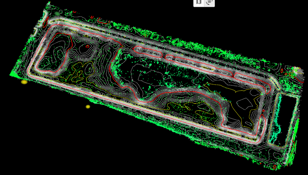
- Contour Generation:
– Generate contour lines from the DEM. Contour lines represent lines of equal elevation on the terrain. Various GIS (Geographic Information System) software packages, such as ArcGIS or QGIS, offer tools to create contours.
- Contour Map Production:
– Once contour lines are generated, they can be styled and formatted to create a topographic contour map. Consider specifying contour intervals based on the desired level of detail.
- Map Analysis and Refinement:
– Analyze the generated map for any inconsistencies or errors. Refine the map as needed, ensuring that it accurately represents the terrain.
- Map Presentation:
– Customize the map’s appearance by adding labels, symbols, and other relevant information. Consider using colors and shading to enhance visual interpretation.
- Quality Assurance:
– Conduct quality checks to ensure the accuracy and reliability of the generated topographic contour map. Validate against ground truth data if available.
- Documentation:
– Document the methodology used, data sources, and any assumptions made during the process. This documentation is essential for transparency and reproducibility.
Keep in mind that the specific software tools and techniques used may vary based on the software available to you and the characteristics of the data. Additionally, the accuracy of the final map depends on the quality of the initial data and the precision of the data processing steps.